Blame Henry David Thoreau, the New York transplants hellbent on proving they’ve escaped to an undiscovered rustic paradise, or the first person to post a #nofilter picture of their boots dangling over a spectacular vista, but getting outside and taking a hike has never been a more popular pastime. Yet the idealized vision of a hike — you know, through verdant glades filled with friendly woodland creatures happily offering tips on the best photo angles for the picnic they set out amid the wildflowers — often collides with a less pleasant reality on the dusty trails of Southern California.
Hiking in L.A. can be a masochistic endeavor, particularly for anyone who might be exploring it as a new hobby or who has been led to believe that it’s an activity that can be done on flat ground. Around here, “trails” are just as likely to be eroded fire breaks going straight up the spine of a ridge; the natural ecosystem is mostly low-lying sage scrub and chaparral full of spiky plants that offer no shade. Many Angelenos view hiking as a substitute for other quick, high-intensity workouts, as exemplified by one of the city’s most popular routes: the East Observatory Trail in Griffith Park. Climbing some 300 feet of elevation over just 0.3 miles, it is somehow both a relentless slog and an unsatisfyingly brief outdoor experience.
The saner and infinitely more pleasant option for hiking to a spectacular Griffith Park view is the Western Canyon trail that departs from the same playground trailhead area as the East and West Observatory Trails, but continues up the main canyon. Instead of fighting through crowds of hypebeasts trying to snag a pic at the same overlook, you may actually find a moment of solitude along the way or be able to have a picnic at the top. You can set yourself up for many more of the park’s best hikes, and you may even walk away interested in hiking again.
What is today known as Western Canyon was once called Mocohuenga Canyon, and at one point it was home to a Gabrielino-Tongva settlement. Whether you begin your hike in the Fern Dell section of the park or at the playground structure, you will head north through the picnic area (when in doubt on this hike, follow the direction of the paved road to your left) until you reach a steep levee that can be climbed via a winding user-created trail on the right side.
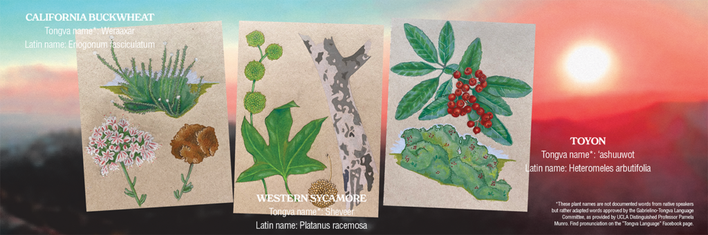
As you walk through the picnic area, you’ll find yourself in a grove of sycamore trees, distinguishable by their beautiful mottled bark (a pattern just begging to be the hottest new 2022 aesthetic) and dangling puff ball seed pods. Sycamore trees naturally grow in the floodplains, washes, and canyons of Southern California; one of the early landmarks of the region, known as far away as Arizona, was an enormous sycamore along the banks of the L.A. River called El Aliso. The tree was cherished as a meeting spot due to the shade of its enormous canopy. Although that site now lies under the 101 Freeway, you can channel the spirit of elders gathering under the stately sycamores of Mocohuenga by posting up at a picnic table in the bottomlands of the canyon.
Above the levee, continue straight, following signs for Griffith Observatory (there is also a turnoff on the right to a short loop trail creatively called the Loop Trail). As you continue up the canyon, you will pass through a shady oak canopy before coming out into a more open, hilly area. The slopes here are covered with black sage, ceanothus, and even a few sticky monkeyflower bushes, but the most reliable flowers found are California buckwheat, which throws up little white pom-pom clusters of flowers from May through October. Those stalks turn a beautiful rust-red in late fall, and the seeds are traditionally harvested to make a type of flour. If you’re thinking of doing some home landscaping, take note of what you see: buckwheat is one of the easiest native plants to grow, requiring almost no watering after it’s established.
You’ll next cross over the main channel of the canyon, which may have water in it after a rain but usually is just choked with thirsty, invasive tree tobacco and castor bean plants. Stay right at the fork, and prepare for a steep climb uphill. Along the sides of the trail are several of the most common midsize trees of the region: laurel sumac, elderberry, and toyon, the official tree of the City of L.A. Legend has it that toyon’s red berries and jagged leaves are what gave Hollywood its name, and decking the halls with boughs of the stuff for Christmas was so popular by the 1920s that the state made it illegal to harvest. Its berries ripen in late fall and are edible, best cooked into a tart sauce. Beloved by birds, toyon is also a great garden plant if you have the space.
Nearing the top of the canyon, you may notice that the hillside across from you looks a little more ragged and barren than some of the landscape above you. This area burned in 2018, and the effects are a great primer in Southern California fire ecology. While fire is natural in this chaparral landscape, frequent fires over a short period of years can clear out many of the larger plants and make room for grasses, especially fast-growing invasives, which in turn burn more readily. This is one more reason, besides the fines, to avoid smoking in the park.
As you round the last turn under some picturesque, tangled oaks at the top of the canyon, you can take a left to continue up to the road, Observatory, and other trails; but you’re also welcome to take a right and make this spot your final destination. A picnic table and great panoramic views over Hollywood and out to the coast await, usually without much of a crowd. Return the way you came or make one of the larger loops described below, but first congratulate yourself on the fact that this manageable stroll through the plants and history of California counts as a hike! It turns out nature is all around you. And best of all, you did it without breaking into a single embarrassing TikTok dance!
Continue Your Hike
Western Canyon also happens to be one of the best entryways into the park and jumping-off points for longer hikes. At the road junction, consider going:
- Right (uphill) to check out the Observatory and complete your loop along the East or West Observatory trails.
- Straight (uphill) and then left for a rugged hike to the top of Mt. Hollywood, the highest point in Griffith Park.
- Left (downhill, then uphill) and through the gate on Mt. Hollywood Drive to take a meandering climb for Hollywood sign views and a flat, shady walk above Brush Canyon.
Tips for Hiking Wherever You Roam
- Drink lots of water, and bring more than you think you’ll need, especially if it’s hot. Plan on at least one liter per hour.
- Wear and bring sun protection, bring or download a map, and consider bringing snacks and first aid supplies, especially for longer trips.
- Try to hike early or late in the day to manage sun and heat exposure; just before dark is also often the best time to see wildlife.
- Practice Leave No Trace principles: Take out any trash you bring, do not approach or feed wild animals, and stay on the designated trail (no “shortcuts” straight uphill).
Directions
The hike described above starts at the playground accessed from the Western Canyon entrance of Griffith Park, off Los Feliz Blvd. at the end of Western Ave. (the one with the bear statue). Round trip from there is about two miles. To reach the hike by public transportation (and add a bonus mile each way), take the B (Red) Line subway to Hollywood/Western. Continue north (uphill) on the west (left) side of Western toward the park, climbing stairs past the American Film Institute. Follow the paved pathway to the entrance of Fern Dell, a shaded grove planted with exotic ornamentals, and take the streamside walk up the hill into the main area of the park. Alternately, from the entrance to the park, follow any paved thoroughfare up into the canyon and toward the playground.